44 Trails Area is Open for Riding!

Updated fire closure map

Updated fire closure map

The 44 Trails zone on the Mount Hood National Forest is open for riding!

Thanks to favorable weather conditions and the efforts of wildland fire crews, the 44 zone is accessible again.

The 17 road remains closed, but 8-Mile, Knebal Springs and the rest of the 44 Trails are open for riding. Ranger Thornton was up in the area on Thursday and said there is moisture in the dirt and the trails are in great shape.

Here is the latest closure info:

Fire Closure Still in Place

It looks like the USFS is going to maintain its existing fire closure for the foreseeable future. Sorry, but the 44 Trails area will be closed for the Labor Day holiday weekend.

The wet and cooler weather has definitely aided in the management and suppression of the Government Flats fire that lead to the road and trail closures but there is still work to be done and fire hazard in the area. The burn has been spotty in areas, which makes mop up efforts a bit more difficult to monitor assess.

What we need is a big multi-day rain cycle. In the mean time, check out rides on Gunsight ridge and the Boulder Lake zone. You can keep tabs on the fire updates at www.inciweb.org/incident/3662/

Latest Fire Closure Update for 44 Trails

USFS 44 Trails closure map

USFS 44 Trails closure map

West winds have cleared the smoke from the Hood River Valley, but the 44 Trails area is still effected by closures. As far as we know, the trails themselves have not been consumed by fire, but there will be active fire suppression efforts in the area and the threat of fire growth, so the USFS is going to keep the zone east and north of the 44 road off limits for a while.

Here’s the latest:

The Mt. Hood National Forest has announced the following closures:

The following campgrounds are closed: Knebal Springs, Lower Eight Mile Crossing, Eight Mile, and Gibson Prairie. Five Mile Lookout is also closed.

The following major trails are closed:

  • Surveyors Ridge # 688 both south and north trailheads
  • Eightmile Loop #496
  • Knebal Springs # 474
  • Bottle Prairie #455
  • North-South #451
  • Oak Ridge #688A
  • Dog River #675
  • Zig Zag #678

Forest Roads 17, 1720, 4430 and all their associated spur roads are closed along with and all other National Forest System Roads and minor trails within the closure area depicted on a map posted on InciWeb.org at http://inciweb.org/incident/maps/3662/

Fire Closure Update for 44 Trails Area

fire map 8/23 update

fire map 8/22 update

Growth of the Government Flats Fire Complex on August 21 is leading to more road/area closures related to the 44 Trails area. Although the decision is not yet final, today’s morning meeting proposes the closure of the FR 44 east of Highway 35 and north to the forest boundary. This closure will effectively close access Knebal Springs, 8-Mile and Surveyors.

The area is experiencing heavy ash and smoke as well (on 8/22), so really, it’s not a good place to try and recreate, regardless of the closure. West winds will help blow smoke out of the area this weekend and should help reduce threat to the 44 Trails area.

The fire has not burned into the trails proper but the risk of it spreading in the area is high given any east wind events.

Here’s a map of the latest fire location. FR 44 runs east/west in the bottom of the image.

Get the latest fire closure information from the USFS news feed

or

the InciWeb.org fire information page

Fire Closures Affect 44 Trails

Aerial view of Government Flats Complex fire

Aerial view of Government Flats Complex fire

Temporary road closures due to the wild fire in Mill Creek (Government Flats Fire Complex) are affecting the 44 trails area.

As per the USFS:Temporary Road and Recreation Area Closure due to Government Flats Fire

The Government Flats fire began to encroach on Forest Service lands Monday, August 19th. To facilitate fire crews and engine traffic the following roads and recreational areas will be temporarily closed as of August 20 until further notice:

Knebal Campground due to the closure on the 1720 Road
1722 (east boundary)
4430 (north of 8 Mile CG)
1720 (posted at both east and west ends)
1700.660
1711.630

stay updated at
http://www.fs.usda.gov/alerts/mthood/alerts-notices
and
http://www.inciweb.org/incident/3662/ 

44 Trails Super Connector Trail Work Day

Sept 14 Work Day PosterWe’ve got a plan for what we hope is the final trail work day on the new Super Connector Trail: Saturday, September 14, 2013. Similar plan as usual. Meet at 9am at the Little John Snopark on Highway 35 near the 44 Road turn off.

HELMETS and LONG PANTS REQUIRED! (bike helmets are fine). Be sure to bring water, gloves and weather appropriate clothing, ’cause we work rain or shine. New York City Subs is kicking in lunch for the day! And there’s going to be a great prize raffle at the end of the trail work day.

Plan on a few hours of trail work and an afternoon ride!

We’ve rescheduled our fall fundraising event for October (date tba soon). See ya on the 14th and thanks for helping grow the 44 Trail network!

44 Trails in Great Shape

Knebal springs parking lot

Knebal Springs parking lot

With the riding around town in Hood River limited by fire closures, I figured it was a good excuse to take a day away from work and head out for a longer day of riding up in the 44 zone on the Mt Hood National Forest. Sadly, it was only my second day of riding the 44 trails this summer, but that only made the day that much sweeter.

We hit Knebal, Bottle Prairie, Eight-Mile and checked out progress on the new Super Connector trail. Overall condition of the trails is excellent right now. There are a few soft spots, but the vast majority is fast and flowy.

knebal - eight-mile map

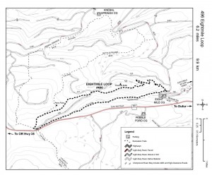
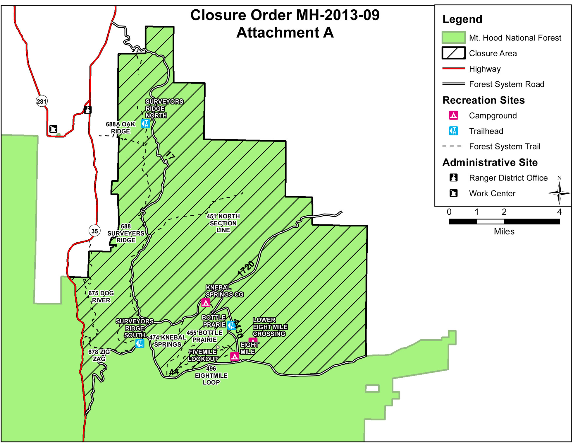
knebal – eight-mile map

We also checked in with Ranger Thornton, who spent the day working on trails up in the Boulder Lake area. He said there are still a couple downed trees, but the high country around Boulder Lake will be in primo condition for the fall riding season. He also noted that the ground hornets are starting to get a little ornery, so watch yourself if you take a lunch break or walk out to a vista point.

Riding from town is convenient and good fun, but spending the better part of the day in the high country on the  44 trail system’s classic cross-country trails is the way to make your week.

44 Trails Super Connector

Thanks to everyone who rallied for the work day on July 14 and thanks to Dog River Coffee, and Dirty Fingers Bike Shop for their support! Trail construction continues, rock work was laid and more tread built.

Mark your calendars, the next round of trail work is scheduled for September 14 to be followed by a fundraising event at Double Mountain Brewing. More details to follow.