Boulder Fire Info

Boulder Fire Update – Mt Hood National Forest: Updated Jul 26, 2023

2023 Boulder Fire

2023 Boulder Fire, Mt Hood National Forest

The good news is that the Boulder Fire was successfully contained after burning about 250 acres around Boulder Lake. The bad news is that some fire closures are still in effect and they impact a number of trails in the Boulder Lake area.

You can read the latest Fire Closure Order here.

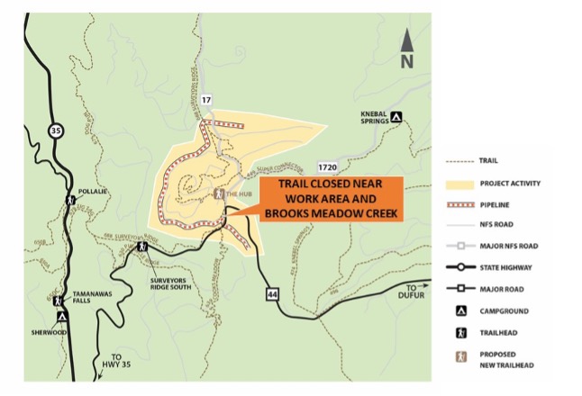
And here is a Boulder Fire Closure Map

____________________________________

Boulder Fire – Mt Hood National Forest: Updated Jul 13, 2023

A fire in the vicinity of Boulder Lake on the Mt Hood National Forest is forcing closures to campgrounds, roads and trails in the area.

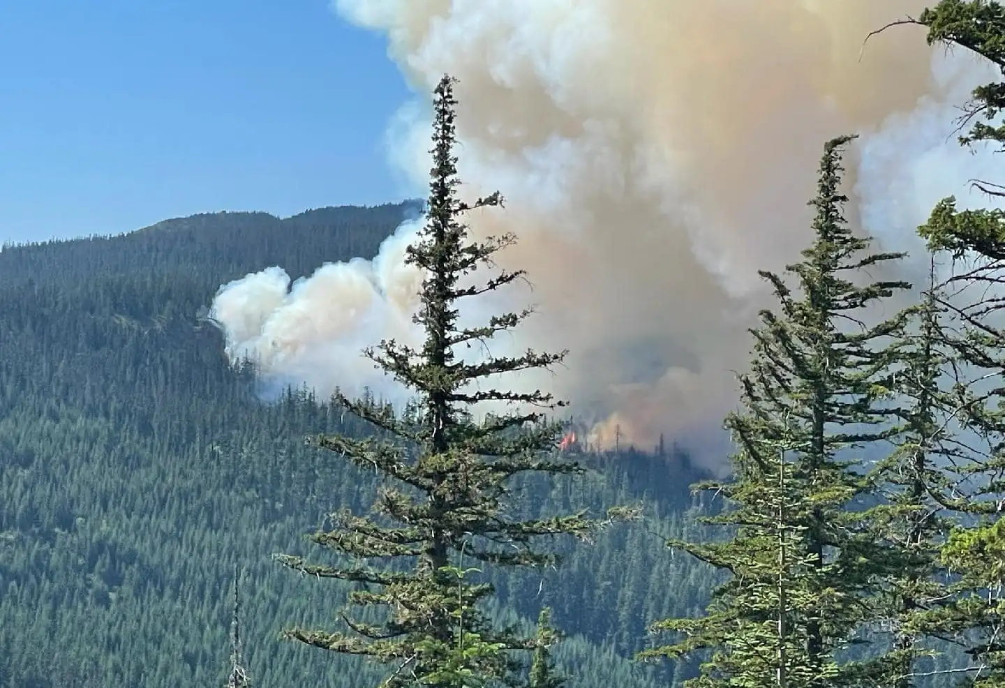
Firefighters are engaged in suppressing the Boulder Fire, which started on July 8 southeast of Mt. Hood on the Barlow Ranger District near Boulder Lake Trailhead. As of July 13, the fire is estimated to be about 300 acres.

The following road, trail and campground closures are in effect. As of July 13, the USFS published an official closure area with additional trails, roads and campgrounds closed due to the Boulder fire. 

Below are the closures of primary interest to mountain bikers, but beside to read the full Boulder Fire Closure document if you are planning any outings east if Highway 35 on the Mt Hood National Forest.

Trail Closures:
Boulder Lake Trail #463 #463A and #463B
Forrest Creek Trail #473
Hidden Meadows Trail #472
Crane Creek Trail #478
Gunsight Ridge #685
Crane Prairie #464
Gumjuwac #480

Road Closures:
FR 4880
FR 4881
FR 4890

Campground Closures:
Boulder Lake Campground
Little Boulder Lake
Bonney Meadows Campground
Badger Lake Campground
Camp Windy
Post Camp Campground

​The fire is burning in a heavily forested area on steep slopes. Four engines, four hotshot crews and two heavy helicopters are actively working on the fire, with additional resources en route.

A larger area closure is in the process of being implemented for public safety. Visitors are asked to avoid the area as conditions can change quickly.

Visit the Mt. Hood National Forest News and Events page or our Facebook page at www.facebook.com/mthoodnf for current information.
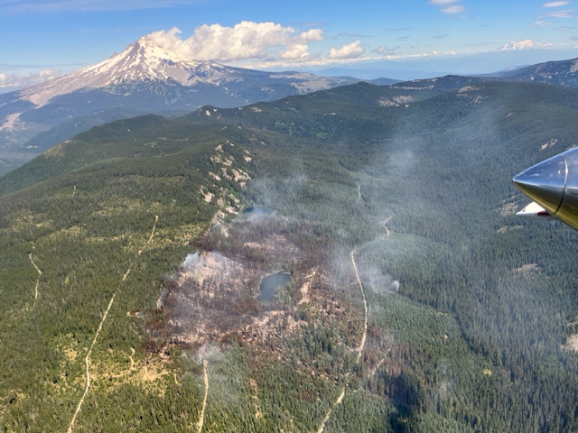
Boulder Fire Map

boulder fire map

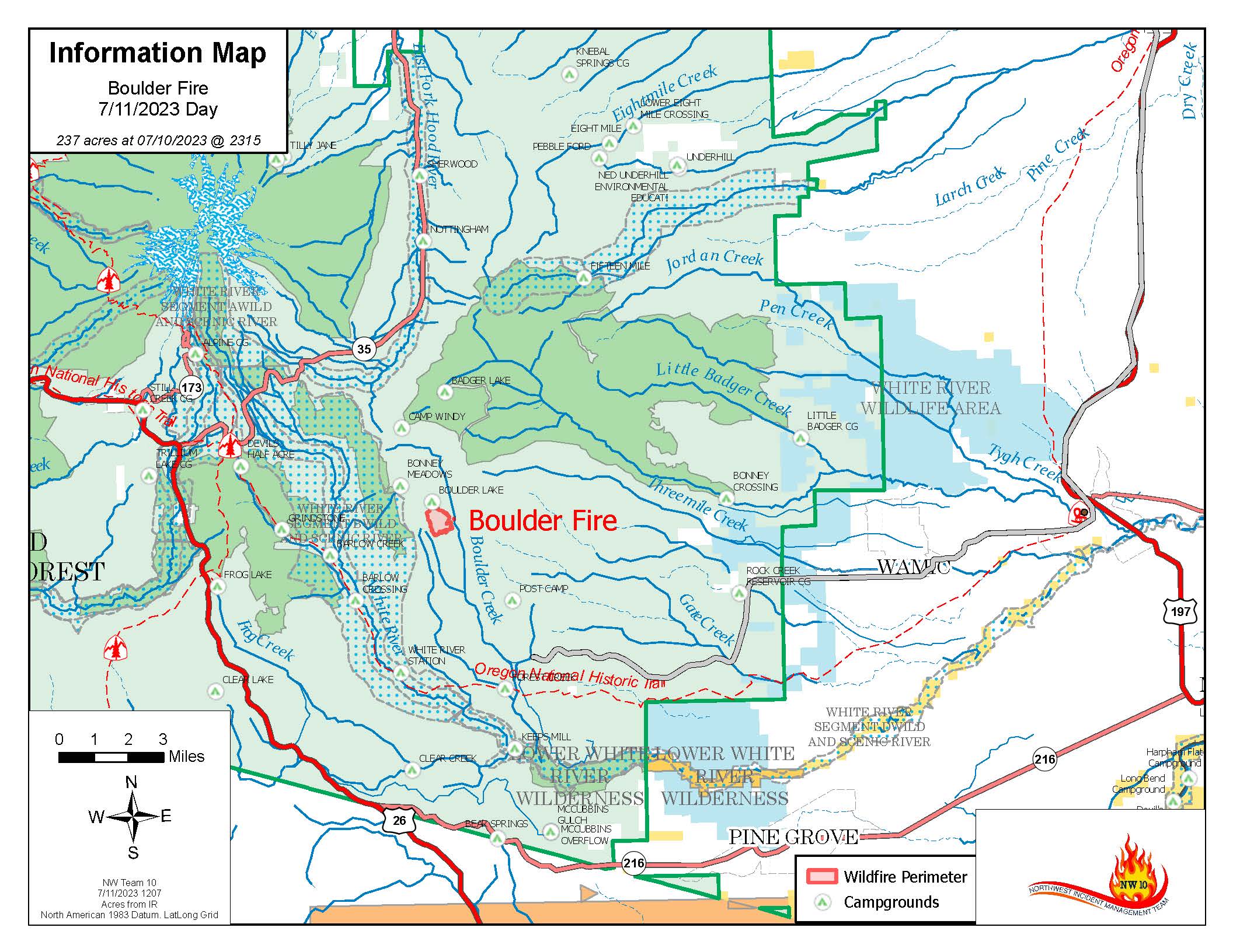
fire map as of July 11


Surveyor’s Ridge – Temp Closure

Surveyor’s Ridge Trail Temporarily Closed at the South End – June 15-27

Heads Up 44 Trails Users – Surveyor’s Ridge Trail #688 in Mount Hood National Forest will be temporarily closed to the public June 15-27 due to active construction for the City of The Dalles Dog River Pipeline Replacement Project.

Please stay safe and use an alternate trail.

What: Trail closed to public access.
Where: Old Surveyor’s Ridge Trail near the work area and Brooks Meadow Creek.

What to expect:
• Closure notices posted at either end of trail.
• Active construction work and equipment in the area.

surveyors ridge temp closure zone-map

Mt Hood 44 Trails Conditions Report

Time to get your pedal on! The largest network of singletrack mountain bike trails on the Mt Hood National Forest is ready for riding. The lower 44 Trails network is log-free!

There is still some lingering snow in the dark corners and upper reaches, but here’s the list of rideable lower 44 network singletrack trails:

SuperConnector #449
Cooks #639 (to 1.5 miles above crossing with 4410 road)
Lookout #450 (clear to junction w/15Mile – upper elevation have snow/mud/trees)
Follow us on Instagram for updates!
Join us for a trailwork day this summer!  – Dates are June 26, July 17, September 25
44 Trails is 100% volunteer organization. All donations go directly to trail maintenance and keeping trails rideable!

Mt Hood National Forest Campfire Ban

mt hood single track mt bikingAugust 5, 2020: The USFS has announced a campfire ban on the Mt Hood National Forest. The ban applies to all camping – developed or not – in and around the 44 Trails zone. The trails remain open and rideable!

Campfires prohibited on Mt. Hood National Forest

Due to dry and hot conditions, campfires are now prohibited across the Mt. Hood National Forest, including in developed campgrounds.

All campfires, charcoal or briquette fires, pellet fires, or any other open fires are prohibited under a Forest Order.  Portable cooking stoves and lanterns using liquefied or bottled fuel are still allowed as they can be instantly switched off.

July was much drier than average, and August and September are predicted to have higher than average temperatures.  These conditions will continue to increase the risk of wildfire- especially on the east side of the forest.  At the same time, Mt. Hood is experiencing extremely high visitation, increasing the number of preventable fires.

Forest Service crews extinguished over 100 abandoned campfires across the Mt. Hood National Forest in July.  With the current dry, hot conditions any wildfire start poses a greater threat to firefighter safety, public safety, and personal property.  This year every preventable fire also increases our firefighters’ risk of exposure to the COVID-19 virus, which could impact our ability to respond to fires as the season continues.

“We know campfires are a big part of camping, but this year especially we all need to do our part to prevent wildfires,” said Dirk Shupe, Fire Management Staff Officer for the Mt. Hood National Forest.  “Fires caused by abandoned or escaped campfires create unnecessary risk for firefighters, our communities, and the forest.”

More forest information and the full text of the Forest Order is on the Mt. Hood National Forest website at:https://www.fs.usda.gov/main/mthood/fire.  The forest also shares recreation, fire, and safety updates on its Facebook and Twitter accounts at: @MtHoodNF.

For more information about the local and regional fire outlook visit: https://gacc.nifc.gov/nwcc/predict/outlook.aspx

USFS Opens Day Use – 44 Trails Status

44 mountain bike trailsThe Mt. Hood National Forest is reopening most developed day-use and trailhead sites to recreational users beginning Friday May 29, 2020. This includes the 44 mountain bike trails!

Recreation Managers are coordinating with campground concessionaires, completing spring maintenance, and training seasonal staff. Several sites will not open immediately, including most campgrounds. These sites will open slowly as they are assessed for public and employee safety.

For a complete list of open and closed recreation sites, please check the Mt. Hood National Forest’s website: www.fs.usda.gov/goto/mthood/conditions

Some facilities, such as vault bathrooms, may not be maintained daily.  It is recommended that all visitors be prepared to provide for their own sanitation and be as self-contained as possible while recreating.

As far as 44 Trails status – the following trails have been logged out and are rideable:

SuperConnector #449
Lookout #450 (upper elevation still has snow)
44 Trails is 100% volunteer run – all donations go directly to trail maintenance
Please remember E-bike use is prohibited on non-motorized trails within the Mt Hood National Forest – read more about E-bike regulations

Go Beyond Racing Donates $1K to 44 Trails Association

Go Beyond Racing – Wy’East Wonder Event Donates $1k to 44 Trails Association

Wy'East Wonder

Wy’East Wonder 50M / 50K – image courtesy Go Beyond Racing

Go Beyond Racing held the first annual Wy’East Wonder 50M and 50K trail run event in June. The event, a point-to-point race run mostly on two ridges, featured Gunsight Ridge and Surveyor’s Ridge trails on the 44 Trails network.

It attracted 250 athletes (the max number) and went off without a hitch. Todd and Renee from Go Beyond Racing stepped up to help with trail maintenance before the event and made a generous $1K donation to the 44 Trails Association (as well as the Hood River Valley High School cross country team) after the event.

Thank you Go Beyond Racing for appreciating the 44 Trail network and the work required to keep the trails clear and well maintained!

Go Beyond Racing Wy'East Wonder donation to 44 Trails

Go Beyond Racing Wy’East Wonder donation to 44 Trails and Hood River Valley Highschool Cross Country Team

44 Trails is run entirely by volunteer support and all financial contributions go directly toward trail maintenance and infrastructure costs like signage, armoring materials and contract labor.


Mt Hood National Forest E-Bike Closure Rules

E-bike closure policy for Mt Hood National Forest and 44 Trails

As e-bikes gain popularity around the country, it is important to understand that all non-motorized trails on the Mt Hood National Forest – including the 44 Trails network – are closed to e-bike use.

The USFS considers all classes of e-bikes to be “motorized” and e-bikes are permitted only on motorized OHV trails and roads within federal land.

Follow this link to read the full 2016 USFS memo on electric bikes and trail management.

So, this means that the 44 Trails network is closed to all classes of e-bike use. And it does not matter whether you are “using” the e-assist or not. The USFS is posting new signs (pictured above) this week at all trail heads on the 44 network.

Where can e-bikes be used on the National Forest?

E-bikes are permitted on roads and trails in our National Forest that are designated for motorized OHV use. There are several locations on the Mt Hood National Forest including Rock Creek OHV and McCubbins Gulch OHV as well as the National Forest road system. The 44 Trails Association encourages e-bike users to consult local bike shops and the USFS Hood River and Barlow district offices for more details on the OHV areas – see links below.

What should you do if you encounter riders on e-bikes?

Well, most importantly, be nice. We are not looking to add to any divide or create one of our own. But it is important to let e-bike users know that essentially all non-motorized trails on National Forest Land are closed to all e-bike use, but that there are places on the National Forest where e-bikes can be ridden – namely any trail or road designated for motorized OHV use..

Where to get more information on places with e-bike access:

Hood River BicyclesDirty Finger Bike ShopMountain View Cycles

USFS Hood River DistrictUSFS Barlow District

Surveyor’s Ridge Re-Route Project June 9

Surveyor's Ridge TrailThe Surveyor’s Ridge Reroute Continues on Saturday June 9

Oh yeah, we’re still working on the Surveyor’s Ridge re-route. Come on up tot he 44 Zone on Saturday, June 9 to lend a hand. Can’t make it? Make a donation! 

The new route adds single track miles and reroutes the trail away from The Dalles Watershed Pipeline, which is about to get replaced, thus disrupting the original Surveyor’s route. READ MORE about the Surveyor’s Ridge Reroute Project and check out project map.

Trail Work Day – Surveyor’s Ridge Reroute Project SATURDAY JUNE 9, 2018

REQUIRED EQUIPMENT:
Hardhats (bike helmets ok), long pants, work gloves and work boots, water. 

WHEN: 
Saturday, June 9, 2018 @ 9am – 2pm (plenty of time for a post-work-project ride)
Meet 9am @ Little John SnoPark on Highway 35
We’ll have coffee thanks to Dog River Coffee in HR and sign-in at the SnoPark and then move up to the work site as a group. Lunch will be provided by NY City Subs in Hood River.

PROJECT:
Handbuilt singletrack on Surveyor’s ridge re-route. We will be doing rough in and route trimming/clearing.

TOOLS:
Surveyor's RidgeHelmet/hardhat (bike helmets ok), long pants, gloves, and work boots required.
Hand tools only – Flat Shovels, McLeods, Metal Rakes, loppers, Pulaskis  (NO chainsaws necessary).


Surveyor's Ridge Trail Reroute

Here is the map showing the approximate route of the Surveyor’s Ridge trail project. The existing trail (yellow) will be disrupted by the new pipeline – the new route (blue) shows the tentative routes to connect with the SuperConnector (brown) near the 17 Road.