44 Trails Area is Open for Riding!

Updated fire closure map

Updated fire closure map

The 44 Trails zone on the Mount Hood National Forest is open for riding!

Thanks to favorable weather conditions and the efforts of wildland fire crews, the 44 zone is accessible again.

The 17 road remains closed, but 8-Mile, Knebal Springs and the rest of the 44 Trails are open for riding. Ranger Thornton was up in the area on Thursday and said there is moisture in the dirt and the trails are in great shape.

Here is the latest closure info:

Fire Closure Still in Place

It looks like the USFS is going to maintain its existing fire closure for the foreseeable future. Sorry, but the 44 Trails area will be closed for the Labor Day holiday weekend.

The wet and cooler weather has definitely aided in the management and suppression of the Government Flats fire that lead to the road and trail closures but there is still work to be done and fire hazard in the area. The burn has been spotty in areas, which makes mop up efforts a bit more difficult to monitor assess.

What we need is a big multi-day rain cycle. In the mean time, check out rides on Gunsight ridge and the Boulder Lake zone. You can keep tabs on the fire updates at www.inciweb.org/incident/3662/

Fire Closure Update for 44 Trails Area

fire map 8/23 update

fire map 8/22 update

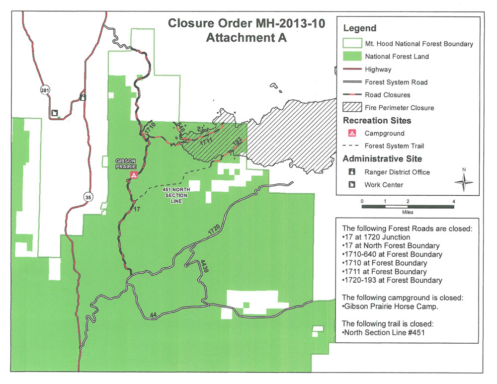
Growth of the Government Flats Fire Complex on August 21 is leading to more road/area closures related to the 44 Trails area. Although the decision is not yet final, today’s morning meeting proposes the closure of the FR 44 east of Highway 35 and north to the forest boundary. This closure will effectively close access Knebal Springs, 8-Mile and Surveyors.

The area is experiencing heavy ash and smoke as well (on 8/22), so really, it’s not a good place to try and recreate, regardless of the closure. West winds will help blow smoke out of the area this weekend and should help reduce threat to the 44 Trails area.

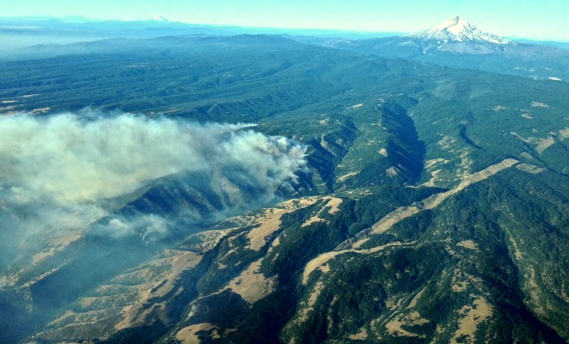
The fire has not burned into the trails proper but the risk of it spreading in the area is high given any east wind events.

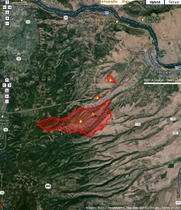
Here’s a map of the latest fire location. FR 44 runs east/west in the bottom of the image.

Get the latest fire closure information from the USFS news feed

or

the InciWeb.org fire information page

Fire Closures Affect 44 Trails

Aerial view of Government Flats Complex fire

Aerial view of Government Flats Complex fire

Temporary road closures due to the wild fire in Mill Creek (Government Flats Fire Complex) are affecting the 44 trails area.

As per the USFS:Temporary Road and Recreation Area Closure due to Government Flats Fire

The Government Flats fire began to encroach on Forest Service lands Monday, August 19th. To facilitate fire crews and engine traffic the following roads and recreational areas will be temporarily closed as of August 20 until further notice:

Knebal Campground due to the closure on the 1720 Road
1722 (east boundary)
4430 (north of 8 Mile CG)
1720 (posted at both east and west ends)
1700.660
1711.630

stay updated at
http://www.fs.usda.gov/alerts/mthood/alerts-notices
and
http://www.inciweb.org/incident/3662/