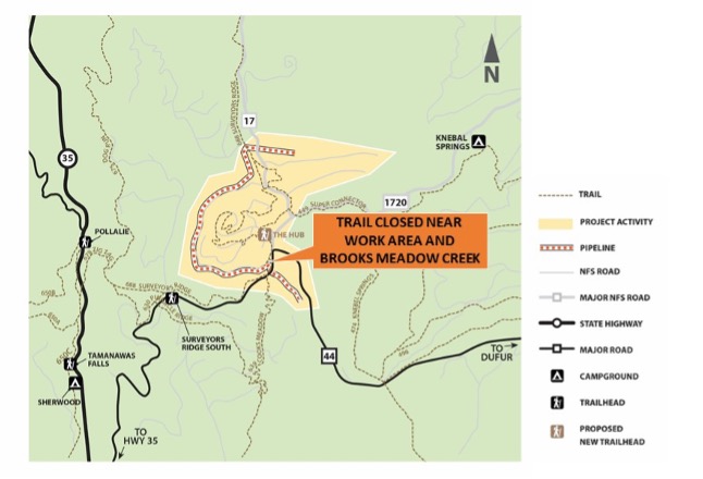
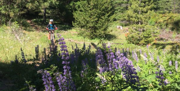
Timberline Bike Park – Comments Requested by Oct 31

Timberline Bike Park – comments needed by Oct 31

Timberline Bike ParkTHE BASIC STORY
As many of you know, a proposal for a Timberline Bike Park was approved by the Forest Service back in 2012 and subsequently halted by a lawsuit against the USFS by a consortium of environmental groups including the Sierra Club, BARK, Friends of Mt. Hood and the NW Environmental Defense Fund.

Well, to make a long story short (you can read the longer story below), a federal judge recently ruled in favor of the USFS and Timberline. The only hurdle for the Timberline Bike Park now is a mandated comment period around the scope of the initial environmental assessment for the project.

GET INVOLVED

This is where you can get involved by sharing your support for the Timberline Bike Park with the USFS before October 31, 2016. Comments should address support for the construction of the bike park without further delay and echo the decision by the courts that no further NEPA process is warranted.

The Forest Service has some requirements on comments:

– You must use the subject as listed below
– Comments must be sent in plain text (.txt), rich text (.rtf), or Microsoft Word
– Comments should not be a copy and paste of a form response.

 
SUBJECT
Timberline Mountain Bike New Information
 
SAMPLE letter (please write your own)

District Ranger Westerbrook,

I am writing in support of the Timberline Ski Area Mountain Bike Trails and Skills Park project. This project has been analyzed and litigated since 2010. During that time I have stood in support of this project. In August 2016 the final National Marine Fisheries Service assessment found no risk Lower Columbia River fish stock. Three years of biological studies concerning Western bumble bees find their range broadening across the forest and no risk of them being federally listed. I recognize we need fish and pollination to live. I am fully satisfied with the comprehensive analysis. Please allow construction of this much desired public recreation asset to move forward on our land. Thank you for your public service.

Sincerley,
YOUR NAME GOES HERE

WHERE TO SEND YOUR LETTER
Email: comments-pacificnorthwest-mthood-zigzag@fs.fed.us
or
Fax: 503-668-1423
or
Physical Address:
Mt Hood National Forest
16400 Champion Way
Sandy, OR 97055-7248

MORE INFORMATION ON THE ISSUES AND PROJECT


The Longer Story

The Timberline Bike Park proposal was approved in 2012 following 2 years of environmental studies, resulting in a comprehensive Environmental Assessment (EA) of the proposal. The Forest Service issued a Decision and Finding of No significant Impact based on the analysis in the EA. This approval was subsequently appealed by a consortium of groups, led by the Friends of Mt. Hood. Upon review by the Region VI Regional Forester, the decision was upheld and the appeal was denied.

Just prior to the start of construction, the CRAG Law Firm, representing Friends of Mt. Hood, the Sierra Club, BARK and the NW Environmental Defense Center, filed suit against the U.S.D.A. Forest Service, and requested an injunction to halt any activity in regards to the proposed Bike Park. Timberline requested and was granted the right to be joined as a co-defendant intervenor with the Forest Service. A federal judge issued an interim injunction pending the court issuing a ruling regarding the merits of the issues in the case. This injunction applied to any trail building, but allowed most of the restoration work to proceed. The restoration work was substantially completed in the Fall of 2015. Subsequent to the initial stages of the law suit, the National Marine Fisheries Service (NMFS) was also named in an amended complaint.

In the Spring of this year, the federal judge ruled in favor of the Forest Service, NMFS and Timberline on most of the issues in the lawsuit, and deferred ruling on the few remaining issues pending Forest Service and NMFS completion of updated reviews of additional information in the form of an additional NFMS Biological Opinion, and the results of further Western Bumblebee surveys.

Yesterday, the Forest Service issued their review of the additional information on their website, their reasoning behind why they feel that the new information is consistent with prior work, concluding that no supplemental EA or other additional NEPA is required and provided for another public comment period regarding their review and conclusions, ending October 31st. The intent of the comment period is to receive input from the public as to whether or not to prepare a supplemental EA or otherwise reopen the EA process, which would further delay implementation of the Bike Park project.

Surveyor’s Ridge Trail Re-Route

Surveyor’s Ridge Trail Re-Route

single track trail constructionThe Mt Hood National Forest announced their decision to authorize the re-route of approximately three miles of the Surveyor’s Ridge trail (trail #668) where it parallels the current water pipeline for The Dalles – near the start of Surveyor’s.

The project is necessary because of a comprehensive project to update The Dalles Watershed Pipeline that will interrupt and conflict with the existing Surveyor’s trail infrastructure. In addition, the Barlow District Ranger, Kameron Sam, authorized the adoption of the pipeline project staging area into a new recreational user parking/staging area once the pipeline project is complete. This is all good news for the multi-use trail system accessible from Forest Road 44.

Here’s the quick snip directly from the decision document to support the Surveyor re-route. Read full Surveyor’s decision document here.

DESCRIPTION OF DECISION

“It is my decision to authorize the rerouting of approximately 3 miles of the existing Surveyors Ridge Trail #688 where it follows the Dalles Pipeline. The north end of the reroute would provide a short loop approximately .7 miles in length for non-motorized recreationists looking for a short distance trail opportunity. The reroute would also connect Surveyors Ridge Trail directly to the Super Connector. The area that will be used for staging for reconstruction of the pipeline would become a trailhead 1.5 acres in size. The trailhead would provide needed centralized parking for the trail system in the vicinity of Forest Road 44.

The existing Surveyors Ridge Trailhead would remain accessible; however, this trailhead is inadequate for the amount of use it receives. The new trailhead would be large enough to accommodate the amount of use the trail system receives. The segment of Surveyors Ridge Trail #688 that would be impacted by the pipeline replacement would remain open to non-motorized travel, although it would not provide the same semi-primitive experience it now provides.”

44 Trails hopes to slide this project into the trail work mix after we finish the Cooks Meadow Extension project early this fall. Stay tuned.

Hood River Mountain Bike Trails – 44 Trails Conditions Report

Hood River Mountain Bike trails

Attention 44 riders, we’ve been busy clearing spring blowdown on Hood River’s finest single track. Here’s the latest update on what trails have been cleared and are ready to ride in the 44 zone for Memorial Day weekend:

44 trails conditions report44 Trails Conditions

Dog River Trail # 675 – open
Surveyor’s Ridge Trail #688 – open
Knebal Springs Trail #474 – open
Bottle Prairie Trail #455- open
Eightmile Trail #496- open
Oak Ridge Trail #688A – open
Super Connector – open

Fifteenmile Trail #456 – Clear
Cooks Meadow Trail #639 -Clear

Higher elevation trails including upper 450, Boulder Lakes area and Bonnie Meadows have not been cleared of blowdown and are still too wet to ride. Please refrain from riding upper elevation areas that are still wet. Riding wet trails degrades the tread and fuels the argument for those who oppose mountain bike use.

Please respect the multi-use aspect of all trails in the 44 Zone and be prepared for new downed trees and changing conditions. There’s still some trail damage on open trails where downed trees have torn up the existing tread or uprooted trees have blown out the tread, so be alert for hazards. In other words, respect your fellow users and use your head! Have fun out there this weekend.

Hood River mountain bike trail conditions

Spring 2016 Trail Update

44 trails mt hoodSpring has come early this year and the high country snow around the 44 zone is rapidly melting away! The 44 road is fully open, but some of the spurs – including the 4410 road to High Prairie – are still blocked by snow.

As usual, winter has left us with a mess of blowdown on the trails. We are working on getting things cleared out, albeit slowly.

Here’s what’s currently been cleared:

  • Surveyor’s Ridge north of the two track (Shellrock Mountain)
  • Knebal from 8-Mile trailhead north to Super Connector
  • Dog River (full)

We hope to have Knebal/Super Connector/Dakine Trail trail clear to the Knebal parking area this week (May 15-20) and, hopefully, 15-Mile, remaining Surveyor’s and more by Memorial Day weekend.

Of course, new trees could come down and there’s always a little more brush leaning in on the trails this time of year until they fully spring back from being buried all winter.

FYI, attempting to ride uncleared trails will yield varying success. Depending on the degree of blowdown, you might get an open mile or two only to find yourself faced with an extensive stretch of climbing and bike carrying. So, if you head up to explore, be ready for an adventure. The spring brushout of blowdown is a chainsaw intensive project that requires being certified by the USFS, so we have a select crew of certified sawyers making their way through the network as time allows. If you are up exploring and hear saw work, please approach slowly!

We should have a new trail conditions update by May 20. In the meantime, the lower elevation trails around the Hood River Valley are in fine form. Happy riding.

Mark your calendars for the following events:
July 9 –
second annual TRAILGATE event – ride 44 zone, eat, drink and music –
details soonread about last year’s event

July 23 – Cooks Meadow Extension Trail work – read about Cooks Meadow Extension
Aug 20 – Cooks Meadow Extension Trail work – read about Cooks Meadow Extension
Sept 24 – Surveyor’s/Super Connect connector – more details on this project in June
Oct 8 – Surveyor’s/Super Connect connector – more details on this project in June


44 Trails Update – Winter 2016

IMG_8112Winter is in full swing up in the 44 zone this year, which puts our trail projects on hold until the snow melts back enough to allow access again. In the meantime, we do have a few projects idling in the background. First is the Cooks Meadow trail extension project that we started in the November. Second is the planning process for the second annual Trailgate event to be held in July of 2016. Finally, third is working with other mountain bike and trail advocacy groups regarding Oregon Wild’s “unfinished business” for a proposed expansion of wilderness designation on the Mt. Hood National Forest.

Cooks Meadow and the National Forest Foundation
44 trails updateCome spring melt, the Cooks Meadow extension trail project will be a top priority along with the annual logout of downed timber on the 44 trail network. We were awarded a grant in from the National Forest Foundation (NFF) in 2015 to help offset the costs of our annual logout and work related to the Cooks Meadow extension project. We were awarded money under the National Forest Foundation Ski Conservation cooper spurFund (SCF). The grant is designed for action-oriented, on-the-ground projects that improve forest health and outdoor experiences on National Forests. Award funds come from guest contributions at ski areas and lodges operating on or adjacent to National Forest. In our case, money came through the Cooper Spur Mountain Resort on Hood’s northeast side. It’s great to have the support of local businesses and their patrons in our efforts to maintain and support the 44 trails! We look forward to getting back on the dirt to put our NFF funding to work this spring!

trailgate 2015Trailgate 2016
Last summer, we held our first ever trail day event that focused on riding not working! Trailgate 2015 was a great success. Based out of the Billy Bob SnoPark on Mt Hood’s Barlow Ranger District, we hosted a couple hundred trail users for a beautiful day of pedaling, eating and music. Well, we filed the paperwork with the USFS to host Trailgate 2016 in July. We’ll be sure to keep you posted! You can also sign up for our mailing list (we never share it with anyone) and you’ll receive notices about 44 Trails Association related events and occasional trail news like fire closures, significant trail condition updates and such.

mt hood wilderness proposal mapWilderness Proposal
Oregon Wild is still working to expand the Mt Hood Wilderness designation in the Boulder Lake / Barlow District area of the Mount Hood National Forest. It’s all part of what they call “unfinished business” related to the 2009 legislation which added wilderness status to new sections of the Mt Hood National Forest.

We value our public lands and consider ourselves active stewards of our local forests and trails. We understand the value of wilderness but we do not support Oregon Wild’s expansion plan. We are working with other mountain bike trail advocacy groups including IMBA, OBRA and NWTA to create a unified and intelligent opposition to Oregon Wild’s efforts. We’ll be sure to keep you posted of any significant news on this front. In the meantime, you can read a little more about Oregon Wild’s plan and our reasons for being opposed as well as how and where to voice your opinion.


Cooks Meadow Extension Day 1

44 trails trail work day

The motley crew of trail workers – slideshow of images at bottom of page

Well, despite the weather taking a serious shift toward the cold and wet, 44 Trails fans turned out in force for our first day of trail work on the new Cooks Meadow extension trail.

Many thanks to everyone who braved the weather and helped rough in several miles of sweet new hand-built single track!

We had trail users from Bend, Vancouver, Portland, Dufur as well as the Hood River Valley and White Salmon. What a great crew! And, truth be told, the weather wasn’t really too bad. We actually had snow in the air and sun breaks.

A big thanks to our sponsors. The following businesses go out of their way to help make our events a success and deserve your business: Fresh Baked Goods from PINE STREET BAKING, Fresh Coffee from DOG RIVE COFFEE, Great Sandwiches and chips from NEW YORK CITY SUBS, Poster Printing from THE UPS STORE in Hood River, Swag from DIRTY FINGERS BIKE SHOP, Hats from PISTIL DESIGNS, Softwoods from DAKINE, monetary donations from FAT TIRE FARM / HOOD RIVER BICYCLES and THE SIXTH STREET BISTRO.

As much as we’d love for the snow to start stacking up in the hills, we’re hoping to pull off two more trail days! Here’s the dates – stay tuned for updates as the date approaches – if you sign up for our e-mail list, you’ll get the notification about the work day!

Saturday, November 21, 2015
DETAILS: Meet 9am at Little John SnoPark on Highway 35
PROJECT: Tread work

Saturday, December 5, 2015
DETAILS: Meet 9am at Little John SnoPark on Highway 35
PROJECT: Tread work

Mt Hood Wilderness

mt hood wilderness proposal mapOregon Wild is still working to expand the Mt Hood Wilderness designation in the Boulder Lake / Barlow District area of the Mount Hood National Forest. It’s all part of what they call “unfinished business” related to the 2009 legislation which added wilderness status to new sections of the Mt Hood National Forest.

The newest additions sought will impact mountain bike recreation on the Barlow District of the Mt. Hood National Forest by closing access to bikes. Specifically, the Boulder Lake zone and the various rides that connect to that area will become closed to bikes. Mt bike access was already impacted by the 2009 Wilderness legislation and this proposal expands the impact.

At this point, the best way to voice your opinion on the proposal is to write our regional reps in the House and Senate – Walden, Wyden, Blumenauer. For those who would like to offer their opposition to increased wilderness designation, here are a few talking points:

  • Between wilderness designation and Bull Run watershed protection, the Mt Hood National Forest has very limited access for multi-use recreation. Adding wilderness designation to more areas further limits an already small multi-use trail system.
  • Contrived wilderness segments with preserved road access weaken the Wilderness Act by not staying true to the Act’s original intent.
  • These are lands which should be managed primarily for recreational value— the areas with true wilderness values on Mt. Hood have already hold wilderness designation.
  • Putting the wilderness blanket over these lands makes it difficult to manage them for recreational value — ie. trail maintenance and construction is limited to hand tools so all blowdown must be cleared without mechanized help (chainsaws).
  • We debated these same areas before the 2009 legislation was passed.  The current wilderness designation reflects a compromise that was reached between interested parties. Now, we’re being asked to compromise on the compromise.
  • The 2009 wilderness designation resulted in the loss of approximately 100 miles of multi-use trails and roads. Traffic and use on the remaining multi-use trails in the system has increased to the point that these trails are showing increased signs of wear and tear, requiring more maintenance.


Fire Closure – Mt Hood National Forest

Badger Lake fire mt hoodIf you have not heard, there is a fire near Badger Lake on the Barlow District of the Mt Hood National Forest.

It’s not directly affecting the bulk of the 44 Trails zone, but there are a number of closures to consider if you are headed up to the area, most notably High Prairie, Gumjuwac, Gunsight and most everything adjacent to Badger lake including the Boulder Lake.

Badger lake Fire mapHere’s the latest official info from the USFS. 

Media Information Line: 503-668-1791/503-668-1776
Public Fire Information: (541) 467-2291
Office hours: 8:00 a.m. to 4:30 p.m.

10/6/15 UPDATE:

The Badger Lake Fire is approximately 60 acres in size and burning in heavy dead and down timber. The fire is located northwest of Badger Lake in the Badger Lake Wilderness. Steep terrain, limited road access and an abundance of snags (standing dead trees) pose challenges for firefighter safety. Retardant was dropped on Forest Road 3550 yesterday with the goal of keeping the fire within the wilderness. Additional retardant has been ordered. Two helicopters continue to work on the fire.

The Badger Lake Fire began on Saturday, October 3, 2015. The cause of the fire is under investigation. Base Camp for the Fire is at Badger Lake Campground.

An area closure is in effect for the area surrounding the fire to protect public and firefighter safety as crews work to contain the fire. The closure includes roads, trails and developed recreation sites. Please contact the Barlow Ranger Station for details or the website address below.

PERSONNEL AND RESOURCES: Approximately 70 personnel, including 2 20 person crews, 4 Type 6 Engines, 1 Type 1 helicopter, and 1 Type 2 helicopter, and 12 rappellers.

SPECIAL MESSAGES/CLOSURES: An area closure is in effect for the Badger Lake Fire. For more information on the closure go to the Mt. Hood NF Closure webpage.

Badger Lake Fire Closure
Effected roads:

  • 3500640 Closed
  • 3500641 Closed
  • 3500642 Closed
  • 3500660 Closed
  • 3540000 Closed
  • 3540011 Closed
  • 3540012 Closed
  • 3540630 Closed
  • 3540640 Closed
  • 3540641 Closed
  • 3550000 Closed
  • 3550620 Closed
  • 4860000 Closed
  • 4860140 Closed
  • 4860160 Closed
  • 4880000 Closed
  • 4891000 Closed
  • 4891120 Closed

Effected Trails:

  • 465         PINE CREEK Closed
  • 477         BADGER CREEK CUTOFF Portion Closed
  • 458         DIVIDE Closed
  • 478         CRANE CREEK Portion Closed – North End
  • 464         CRANE PRAIRIE Portion Closed
  • 466         THREE MILE Closed
  • 479A      BADGER LAKE Closed
  • 480         GUMJUWAC Closed
  • 680         JEAN LAKE Closed
  • 467         POST CAMP Closed
  • 477A      WEST FORK Closed
  • 685B      CAMP WINDY Closed
  • 463         BOULDER LAKE Portion Closed
  • 493         HIGH PRAIRIE Closed
  • 685         GUNSIGHT BUTTE Closed
  • 479         BADGER CREEK Portion Closed (West of Bonney Crossing)

Effected Rec Sites are

  • Badger Lake C.G. Closed
  • Camp Windy C.G Closed
  • Bonney Meadows Closed

Cooks Meadow Extension Approved

view of mt hood from cooks meadow extension trail

view of mt hood from cooks meadow extension

Well, it took a little longer than we were hoping, but the Hood River Ranger District just approved the proposed Cooks Meadow Extension Trail that we have been hoping to begin work on this fall.

44 Trails Association would like to thank all who commented and added their support  during the public process for the new trail.

cooks meadow extension map

map of area

The new trail will move the route off of the 4410 road and create approximately four miles of new single track! A short section (2/10 of a mile) at the very top, which crossed the High Prairie Meadow, was adjusted based on public comment. Although it would have been nice to roll through the meadow, we can live with 2/10 of a mile on the road to connect to the parking lot.

You can read the full Cooks Meadow decision document from the district ranger here.

We will announcing our work party schedule before the end of September and hope to hold at least one trail work day this October. Stay tuned for details or sign up for our e-mail list to be notified automatically.

Once completed, the Cooks Meadow extension will connect the lower Cooks Meadow trail with High Prairie and the 450 trail, creating a new loop ride and further working toward our goal of an interconnected trail system worthy of destination riding on the Mt Hood National Forest.

44 Trails Map

44 trails mapWe recently completed a digital map of the 44 Trails area that is designed for use on your mobile device. The geo-referenced PDF is viewed with the free Avenza PDF Map App (available for iPhone, Android and Windows phones). The map shows your location, offers your coordinates and allows you to navigate.

At this point, we’ll call it a beta version of the map, as we have not been able to check every trail. Think of it as a good general reference.

You can get your free copy of the map by signing up for our e-mail list. Once you sign up, you’ll get an e-mail that includes a download link for the map.

How to get the free 44 Trails Mobile Map:

1. Download the Avenza Map App (free) on your mobile device.
2. Sign up for our mailing list and a link to download the 44 Trails map will be sent to you.
3. Open 44 Trails map with Avenza on your device

The map is for general reference only and is provided without a warranty of any kind, either expressed or implied. Use of this map is at your own risk and discretion.

Sign up for our mailing list to receive the 44 Trails Map for free!